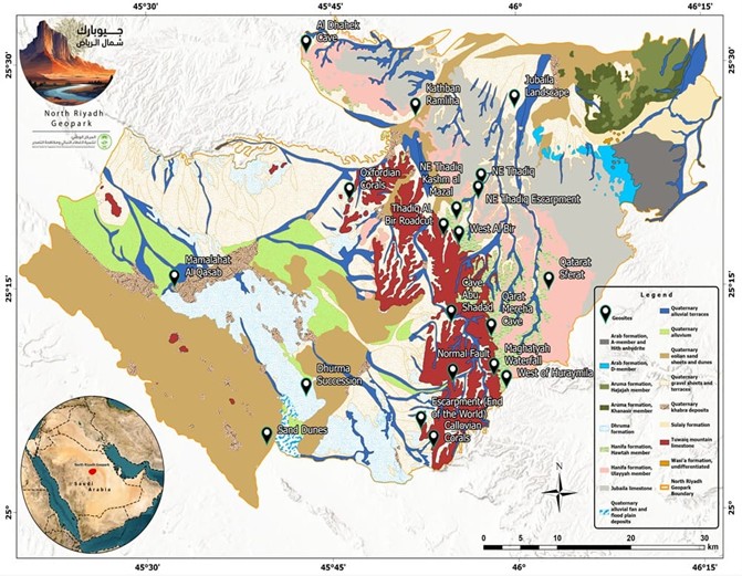
About
North Riyadh Geopark

Exploring

North Riyadh Geopark

  • North Riyadh Geopark situated in the northern region of the riyadh province.
  • Thadiq City was founded in 1079 AH.
  • Thadiq City earned the esteemed moniker “mother of guns” for its vital role in the foundation of the saudi kingdom under the visionary leadership of his majesty Abdul Aziz Bin Abdul Rahman Al-Saud.

GEOLOGY OF THE

North Riyadh GEOPARK

A geopark is an area that contains unique landforms, biodiversity, cultural heritage, and intangible assets, providing an opportunity to study various geomorphological features and associated processes. Geological features include rocks, sediments, soil, and fossils, which carry valuable information about the geological evolution of a region. Saudi Arabia's national policy, Vision 2030, focuses on diversifying the economy, with tourism being one of the key strategic sectors. While the development of geoparks in Saudi Arabia is still in its early stages, geoheritage research has been underway for some time. However, there is limited literature connecting the geopark concept with both national and global policies.
The North Riyadh Geopark (aUGGp) covers an area of approximately 3,221 km² and is located around 140 kilometers northwest of Riyadh, Kingdom of Saudi Arabia. The geopark is defined by well-known geographic landmarks such as Tuwaiq Mountain, the King Abdulaziz Royal Reserve to the east, and King Fahd Highway Road 505 to the west. It is also surrounded by an asphalt road network on the north and east boundaries.
The boundary of the North Riyadh Geopark encompasses various landforms and geological features that require further exploration. The region experiences an arid climate, with temperatures ranging from an average of 15°C in winter to 35.5°C in summer. Precipitation is mainly observed in the spring, with an average of 22.4 mm (weather data of Riyadh, Alghamdi et al. 2021).
The geopark is home to one of the ancient cities established in the 11th century AH, called Thadiq. According to Ibn Rabia, the construction of Thadiq dates back to 1079 AH. The first people to settle in Thadiq were the Awasij from the Badarin Al-Dawasir region, followed by families from various tribes, including Bani Tamim, Al-Qahtain, Bani Khalid, Shammar, and others. Thadiq is located about 150 km north of Riyadh. The region is renowned for its beautifully decorated museum, and visitors can walk through the old village and see the ruins, accompanied by geoheritage sites. These areas boast a variety of geological features, including mountains, canyons, caves, and fossils.
North Riyadh aUGGp has three major pillars: 1. Globally significant geomorphological assets, including Table Mountain. 2. Jurassic and Cretaceous rocks, which were deposited in the ancient shallow Tethys Ocean, are covered by Quaternary sediments such as sand dunes and sabkhas. 3. The connection with the petroleum geological heritage, where the exposed rocks of North Riyadh Geopark are equivalent to some of the largest oil reserves beneath the surface in the Kingdom of Saudi Arabia. 4. Active social participation and the preservation of geological heritage

NATURE

at North Riyadh Geopark

  • The eastern regions have lower elevations, the western areas boast higher elevations that gradually rise and become more rugged as we move towards the southern parts.
  • The slope of the site demonstrates variations. it ranges from 20 to 40% when descending from the north to the southeast, forming an extension of the tuwaiq mountain range.
  • The western region features a gentler slope, ranging from 10 to 20%, characterized by sand dunes that soar to heights exceeding 10 meters.
  • The site’s natural features include numerous depressions and terraces formed within the mountains, which eventually flow into the waterways.
  • The area is distinguished by an abundance of valleys and watercourses that branch out from larger valleys.
  • The presence of numerous coral reefs in the area indicates that the region was submerged beneath the sea in the past.
  • These coral reefs, formed by marine organisms, suggest a rich maritime history and the existence of clear, nutrient-rich waters during that period.

Map of

North Riyadh GEOPARK

  • Size: 3,22km2
  • Governorate: Thadiq
  • City: Riyadh, KSA
  • Coordinates: (25.2962190, 45.8645017)
  • Population: 17,000 inhabitants
  • Av. High Temperature: 35.5 C
  • Av. Low Temperature: 15 C
  • Warmest Month: August
  • Coolest Month: January
map
 
Prodan Oasis

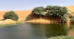
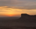
An oasis surrounded by sand dunes in the desert and fringed by palm trees

 
Prodan Meadow

It is a kindergarten characterized by its beauty, surrounded by sand dunes, surrounded by wild plants and palm trees, and a beautiful place for picnics and camping.

 
AL-Jirisi Historical Castle

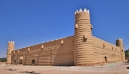
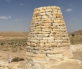
A historical castle belonging to the Jirisi family, which has a history dating back to before the third Saudi state

 
Water Pools

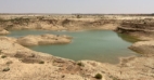
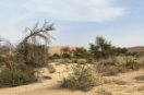
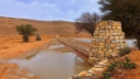
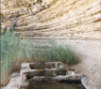
The rainwater catchment center over the years formed a geological nature around it, which contributed to the increase and diversity of the vegetation cover around it

 
Khashm Al-Hussan Mountain

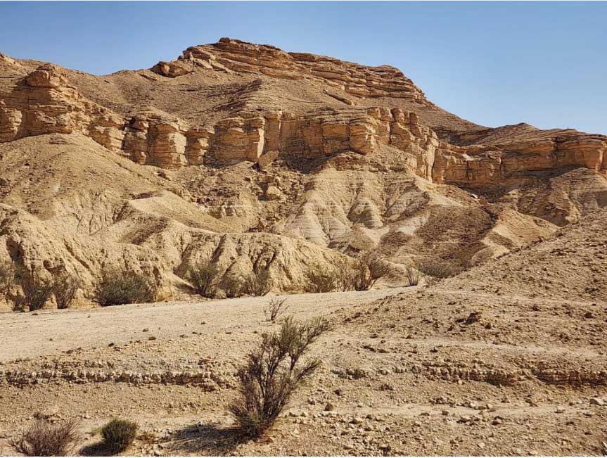
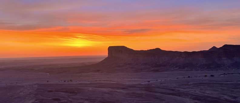
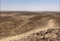
As the highest point in North Riyadh Geopark, Khashm Al-Hussan Mountain stands as both a geographical landmark and an invitation to explore the awe-inspiring heights of this remarkable natural sanctuary.

 
Overview

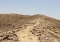
A high mountainous area with a beautiful view of Khashm Al-Hussan Mountain and the charming nature around it

 
Ghar Al-Amir

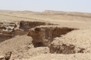
A caveroom formed from the geological nature of the site and has been restored to be a picnic area in the site and is considered the largest cave room in the site

 
Al Gurabah

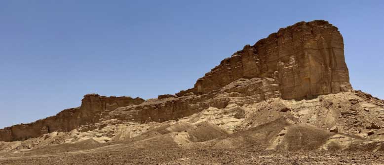
A mountain distinguished by its history, near which fossilized coral reefs are located

 
Shuaib Abithran Reserve

A Reserve in the area to protect the environment and wildlife.

 
Community Work

The local residents made many community contributions that promote the governorate, such as restoring archaeological monuments and contributing to increasing the vegetation cover.

 
Um Al-Jaraad

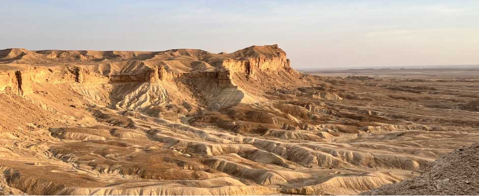
It is considered one of the distinctive and beautiful areas for walking in times of rain and contains a landmark

 
Al-Bilad Al-Wusta

It is a village located in the Al-Safrat area, and there are some farms and some distinctive areas

 
Historical Inscriptions

Distinctive archaeological inscriptions on the mountains adjacent to Wadi Al-Safrat.

 
Shuaib Al-Fahaheel

An area full of vegetation and large trees, and he amphitheater in Shuaib, Fahaheel, is almost 20 years old and is the main cause of vegetation

 
Historical North Riyadh

It is considered one of the distinguished historical areas in North Riyadh, and there are many farms in it, as well as markets and the old North Riyadh market

 
Aba Al-Salabikh

A caveroom in a protected area characterized by drops of water dripping from two adjacent areas, one fresh and the other salty.

 
Qarat Muriha

A mountain considered to be roughly the middle between mountains.

 
Ghar Qarat Muriha

It is one of the cave room present in the area, and the Marrow Bird resides within it

 
Maghatyah Waterfall

The mountains were formed due to strong water drifts that changed the shape of the mountain as a water waterfall in the rainy season

 
Jadat Maghatyah

The area is 2,500 years old, There are old mountain paths that connect to each other, and there is a main passage

Today

North Riyadh Geopark Welcomes A Diverse Array Of Visitors, Ranging From Tourists, Nature Enthusiasts To Scientists And Archeologists.

TO MAKE TOUR RESERVATIONS

Learn More